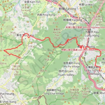
徑口坑 營盤 泰亨坑
Hong Kong Hike
- Distance: 16.7 Km
- Elevation gain: 1,050 m
- Maximum elevation: 487 m
- Elevation loss: 1,095 m
- Minimum elevation: 3 m
- Moving time: 4 h 21 m
- Moving speed: 3.8 Km/h
- Maximum speed: 29.6 Km/h
- Total time: 7 h 27 m
- Global speed: 2.2 Km/h
Interactive trail map
Trail profile
About this trail
Name: 徑口坑 營盤 泰亨坑 trail, distance, elevation, map, profile, GPS track
Coordinates: 22.45172 114.09142 22.47745 114.16303
Other hiking, mountain biking, running and outdoor activity trails
Click on a trail to view its statistics, map and profile.
Cloudy Hill
China > Hong Kong > North District > Kwan Tei Tsuen > Po Kak Tsai
Distance: 9.0 Km • Elevation gain: 469 m • Maximum elevation: 417 m
石塘左左 担水徑坑
China > Hong Kong > Yuen Long District > Sheung Che
Hike
Distance: 5.9 Km • Elevation gain: 438 m • Maximum elevation: 474 m
Wilson Trail Full Route
China > Hong Kong > Hong Kong Island
Distance: 81.2 Km • Elevation gain: 4,430 m • Maximum elevation: 613 m