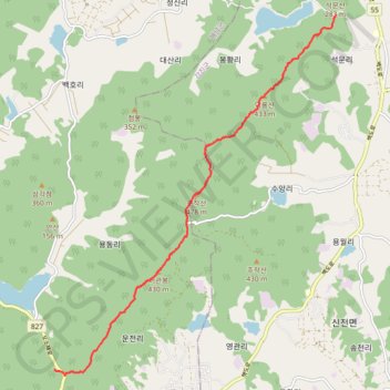
덕룡-주작-오소재(샘)
- Distance: 12.1 Km
- Elevation gain: 762 m
- Maximum elevation: 462 m
- Elevation loss: 658 m
- Minimum elevation: 54 m
- Moving time: 5 h 14 m
- Moving speed: 2.3 Km/h
- Maximum speed: 7.3 Km/h
- Total time: 6 h 56 m
- Global speed: 1.7 Km/h
Interactive trail map
Trail profile
About this trail
Name: 덕룡-주작-오소재(샘) trail, distance, elevation, map, profile, GPS track
Start: Seongmun 1 Bridge, Doam-myeon, Gangjin-gun, South Jeolla, 59250, South Korea (34.55458 126.71633)
End: 오소재로, Sinwol-ri, Haenam-gun, South Jeolla, 59051, South Korea (34.48461 126.64891)
Coordinates: 34.48349 126.64891 34.55458 126.71633
Other hiking, mountain biking, running and outdoor activity trails
Click on a trail to view its statistics, map and profile.
덕룡산, 주작산, 두륜산
South Korea > Gangjin-gun > Doam-myeon
Distance: 20.7 Km • Elevation gain: 1,325 m • Maximum elevation: 660 m