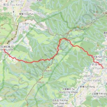
石塘左左 担水徑坑
Hike
- Distance: 5.9 Km
- Elevation gain: 438 m
- Maximum elevation: 474 m
- Elevation loss: 457 m
- Minimum elevation: 24 m
- Moving time: 2 h 6 m
- Moving speed: 2.8 Km/h
- Maximum speed: 19.6 Km/h
- Total time: 3 h 42 m
- Global speed: 1.6 Km/h
Interactive trail map
Trail profile
About this trail
Name: 石塘左左 担水徑坑 trail, distance, elevation, map, profile, GPS track
Start: Fan Kam Road, Sheung Che, Yuen Long District, New Territories, Hong Kong, China (22.46113 114.10374)
Coordinates: 22.45419 114.10372 22.46461 114.14123
Other hiking, mountain biking, running and outdoor activity trails
Click on a trail to view its statistics, map and profile.
徑口坑 營盤 泰亨坑
China > Hong Kong > Yuen Long District > Sheung Che
Hong Kong Hike
Distance: 16.7 Km • Elevation gain: 1,050 m • Maximum elevation: 487 m