Middle Sister and Mount Chocorua Loop
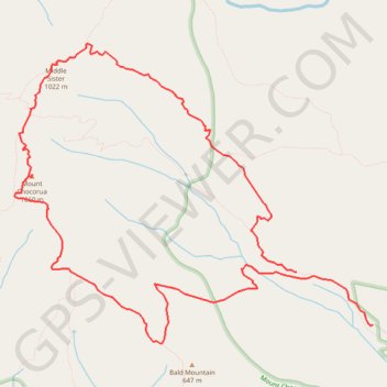
From the Piper Trailhead in White Mountain National Forest, this loop follows Piper Trail into the forest, turns onto Nickerson Ledge Trail, and climbs toward Carter Ledge, a quieter ridge route known for open ledges, views of Mount Chocorua, and the Three Sisters.
The itinerary continues over the Three Sisters to Middle Sister, then crosses ledgy ground toward the rocky summit of Mount Chocorua, one of New Hampshire’s most recognizable peaks and part of the Mount Chocorua Scenic Area.
The return descends by Liberty Trail, passes the historic Jim Liberty route and cabin area, joins Hammond Trail along the ledgy south ridge, and completes the loop on Weetamoo Trail past brooks, forest, outlooks, and Weetamoo Rock before rejoining Piper Trail.
#Hiking #Loop #Mountain #Forest #Nature #Summit #Ridge #Ledge #Wilderness
- Distance: 13.2 Km
- Elevation gain: 824 m
- Maximum elevation: 1,049 m
- Elevation loss: 902 m
- Minimum elevation: 239 m
- Moving time: 4 h 27 m
- Moving speed: 3.0 Km/h
- Maximum speed: 5.6 Km/h
- Total time: 5 h 15 m
- Global speed: 2.5 Km/h
Interactive trail map
Trail profile
- Distance: 13.2 Km
- Elevation gain: 824 m
- Maximum elevation: 1,049 m
- Elevation loss: 902 m
- Minimum elevation: 239 m
- Moving time: 4 h 27 m
- Moving speed: 3.0 Km/h
- Maximum speed: 5.6 Km/h
- Total time: 5 h 15 m
- Global speed: 2.5 Km/h
About this trail
Name: Middle Sister and Mount Chocorua Loop trail, distance, elevation, map, profile, GPS track
Start: Piper Trail, Albany, Carroll County, New Hampshire, United States (43.94537 -71.23906)
End: Piper Trail, Albany, Carroll County, New Hampshire, United States (43.94042 -71.22923)
Coordinates: 43.93869 -71.27553 43.96663 -71.22923
Other hiking, mountain biking, running and outdoor activity trails
Click on a trail to view its statistics, map and profile.