Bells Canyon Trail to Lower Falls
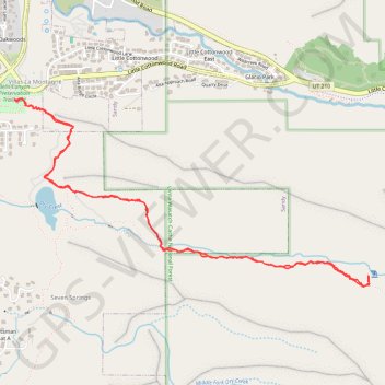
From Bell Canyon Preservation Trailhead, the route joins Bells Canyon Trail and climbs through open Wasatch foothills toward Lower Bells Canyon Reservoir, with valley views widening behind the path.
Beyond the reservoir, the itinerary follows Bells Canyon Creek into a more enclosed canyon, where the track shifts from a broader dirt way to a rougher mountain trail among brush, granite outcrops, woodland, and a creek crossing.
The final approach steepens on rocky single-track and ends at Lower Bell Canyon Waterfall, a lively cascade set among boulders and forested Wasatch canyon walls.
#Hiking #Mountain #Lake #River #Waterfall #Forest #Nature
- Distance: 7.7 Km
- Elevation gain: 475 m
- Maximum elevation: 2,066 m
- Elevation loss: 475 m
- Minimum elevation: 1,618 m
- Moving time: 2 h 54 m
- Moving speed: 2.6 Km/h
- Maximum speed: 6.0 Km/h
- Total time: 3 h 59 m
- Global speed: 1.9 Km/h
Interactive trail map
Trail profile
- Distance: 7.7 Km
- Elevation gain: 475 m
- Maximum elevation: 2,066 m
- Elevation loss: 475 m
- Minimum elevation: 1,618 m
- Moving time: 2 h 54 m
- Moving speed: 2.6 Km/h
- Maximum speed: 6.0 Km/h
- Total time: 3 h 59 m
- Global speed: 1.9 Km/h
About this trail
Name: Bells Canyon Trail to Lower Falls trail, distance, elevation, map, profile, GPS track
Coordinates: 40.56029 -111.79818 40.57144 -111.77043
Other hiking, mountain biking, running and outdoor activity trails
Click on a trail to view its statistics, map and profile.