Giant Mountain and Rocky Peak Ridge
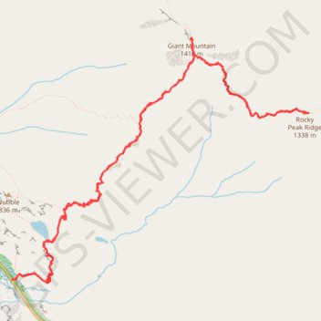
Starting from Chapel Pond, the route climbs the Ridge Trail through forest and exposed rock to Ridge Lookout, with early views over Chapel Pond, then reaches Giant Washbowl before linking toward the Roaring Brook Trail junction.
The ascent continues over steep open slabs and long ridge sections to Giant Mountain, a prominent Adirondack High Peak overlooking Keene Valley and the Champlain Valley.
Beyond Giant, the itinerary follows the East Trail across the col toward Giant East Slide Lookout and Rocky Peak Ridge, where the scenery opens to broad Adirondack ridges, Mary Louise Pond, Lake Champlain, and the distant Green Mountains before returning along the same mountain corridor.
#Hiking #Mountain #Nature #Forest #Lake #Park #Wilderness #Adirondacks #Summit #Ridge #Lookout #Panorama
- Distance: 13.1 Km
- Elevation gain: 1,336 m
- Maximum elevation: 1,387 m
- Elevation loss: 1,334 m
- Minimum elevation: 492 m
- Moving time: 5 h 8 m
- Moving speed: 2.6 Km/h
- Maximum speed: 5.2 Km/h
- Total time: 5 h 45 m
- Global speed: 2.3 Km/h
Interactive trail map
Trail profile
- Distance: 13.1 Km
- Elevation gain: 1,336 m
- Maximum elevation: 1,387 m
- Elevation loss: 1,334 m
- Minimum elevation: 492 m
- Moving time: 5 h 8 m
- Moving speed: 2.6 Km/h
- Maximum speed: 5.2 Km/h
- Total time: 5 h 45 m
- Global speed: 2.3 Km/h
About this trail
Name: Giant Mountain and Rocky Peak Ridge trail, distance, elevation, map, profile, GPS track
End: Ridge Trail, Town of Keene, Essex County, New York, United States (44.13841 -73.74365)
Coordinates: 44.13811 -73.74377 44.16118 -73.70478
Other hiking, mountain biking, running and outdoor activity trails
Click on a trail to view its statistics, map and profile.