
Goat Canyon Trestle
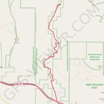
Starting near Carrizo Gorge Road at the desert edge of Anza-Borrego, the route enters Carrizo Canyon, follows the broad wash below the surrounding ridges, and gradually draws into the rougher narrows of Carrizo Gorge.
As it bends northward, the itinerary passes boulder-strewn canyon floor, dry side gullies, sparse desert vegetation, abandoned railway traces, and widening views toward Goat Canyon.
The hike ends at the Goat Canyon Trestle, the remote redwood landmark of the former San Diego and Arizona Eastern Railway, where the “Impossible Railroad” meets the wild desert relief of Anza-Borrego.
#Hiking #Canyon #Desert #Nature #Park #Railway #Wilderness
- Distance: 12.7 Km
- Elevation gain: 373 m
- Maximum elevation: 832 m
- Elevation loss: 510 m
- Minimum elevation: 663 m
Interactive trail map
Trail profile
- Distance: 12.7 Km
- Elevation gain: 373 m
- Maximum elevation: 832 m
- Elevation loss: 510 m
- Minimum elevation: 663 m
About this trail
Name: Goat Canyon Trestle trail, distance, elevation, map, profile, GPS track
Start: Carrizo Gorge Road, San Diego County, California, 91934, United States (32.64763 -116.18641)
Coordinates: 32.64763 -116.19983 32.72963 -116.18303