Thank you for supporting this site ❤️
Make a donation
Make a donation
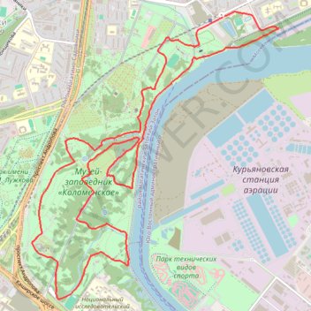
Осень в Коломенском
- Distance: 11.1 Km
- Elevation gain: 204 m
- Maximum elevation: 169 m
- Elevation loss: 204 m
- Minimum elevation: 113 m
- Moving time: 1 h 1 m
- Moving speed: 10.7 Km/h
- Maximum speed: 15.7 Km/h
- Total time: 1 h 1 m
- Global speed: 10.7 Km/h
Interactive trail map
Thank you for supporting this site ❤️
Make a donation
Make a donation
Trail profile
- Distance: 11.1 Km
- Elevation gain: 204 m
- Maximum elevation: 169 m
- Elevation loss: 204 m
- Minimum elevation: 113 m
- Moving time: 1 h 1 m
- Moving speed: 10.7 Km/h
- Maximum speed: 15.7 Km/h
- Total time: 1 h 1 m
- Global speed: 10.7 Km/h
Thank you for supporting this site ❤️
Make a donation
Make a donation
About this trail
Name: Осень в Коломенском trail, distance, elevation, map, profile, GPS track
Coordinates: 55.65156 37.65549 55.67543 37.69176
Thank you for supporting this site ❤️
Make a donation
Make a donation
Other hiking, mountain biking, running and outdoor activity trails
Click on a trail to view its statistics, map and profile.
Moscow Green Route
Route created on plotaroute.com
Distance: 129.1 Km • Elevation gain: 953 m • Maximum elevation: 248 m