Thank you for supporting this site ❤️
Make a donation
Make a donation
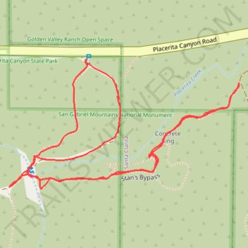
Placerita Canyon/Walker Ranch
- Distance: 1.7 Km
- Elevation gain: 52 m
- Maximum elevation: 581 m
- Elevation loss: 52 m
- Minimum elevation: 552 m
- Moving time: 27 m 58 s
- Moving speed: 3.7 Km/h
- Maximum speed: 7.3 Km/h
- Total time: 33 m 50 s
- Global speed: 3.1 Km/h
Interactive trail map
Thank you for supporting this site ❤️
Make a donation
Make a donation
Trail profile
- Distance: 1.7 Km
- Elevation gain: 52 m
- Maximum elevation: 581 m
- Elevation loss: 52 m
- Minimum elevation: 552 m
- Moving time: 27 m 58 s
- Moving speed: 3.7 Km/h
- Maximum speed: 7.3 Km/h
- Total time: 33 m 50 s
- Global speed: 3.1 Km/h
Thank you for supporting this site ❤️
Make a donation
Make a donation
About this trail
Name: Placerita Canyon/Walker Ranch trail, distance, elevation, map, profile, GPS track
Coordinates: 34.37596 -118.44409 34.37803 -118.43967
Thank you for supporting this site ❤️
Make a donation
Make a donation