Make a donation
GoMap__2025_11_02__13_31_29
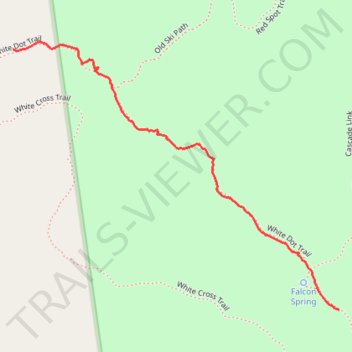
- Distance: 1.1 Km
- Elevation gain: 298 m
- Maximum elevation: 844 m
- Elevation loss: 0 m
- Minimum elevation: 545 m
- Moving time: 35 m 15 s
- Moving speed: 1.9 Km/h
- Maximum speed: 4.2 Km/h
- Total time: 1 h 18 m
- Global speed: 0.8 Km/h
Interactive trail map
Make a donation
Trail profile
- Distance: 1.1 Km
- Elevation gain: 298 m
- Maximum elevation: 844 m
- Elevation loss: 0 m
- Minimum elevation: 545 m
- Moving time: 35 m 15 s
- Moving speed: 1.9 Km/h
- Maximum speed: 4.2 Km/h
- Total time: 1 h 18 m
- Global speed: 0.8 Km/h
Make a donation
About this trail
Name: GoMap__2025_11_02__13_31_29 trail, distance, elevation, map, profile, GPS track
Start: White Dot Trail, Jaffrey, Cheshire County, New Hampshire, 03444, United States (42.85346 -72.09247)
End: White Dot Trail, Jaffrey, Cheshire County, New Hampshire, 03444, United States (42.85836 -72.10081)
Coordinates: 42.85346 -72.10081 42.85849 -72.09247
Make a donation
Other hiking, mountain biking, running and outdoor activity trails
Click on a trail to view its statistics, map and profile.
Mount Monadnock Loop via White Dot Trail and White Cross Trail in Monadnock State Park
United States > New Hampshire > Cheshire County > Jaffrey
The Mount Monadnock Loop offers a diverse hiking experience with a combination of challenging rock scrambles and scenic views. The ascent via the White Dot Trail is steep and demanding, with plenty of rocky terrain, while the White Cross Trail provides a somewhat gentler but still rugged descent, featuring…
Distance: 6.4 Km • Elevation gain: 529 m • Maximum elevation: 948 m
Bald Rock, Paradise Valley trail and others in the Monadnock State Park
United States > New Hampshire > Cheshire County > Jaffrey
Distance: 7.5 Km • Elevation gain: 550 m • Maximum elevation: 890 m
Lost Paradise Valley Loop Trail
United States > New Hampshire > Cheshire County > Jaffrey
Distance: 7.7 Km • Elevation gain: 550 m • Maximum elevation: 890 m
Make a donation