
Sungei Buloh Wetland Route
Enjoy the tranquility and serenity of the mangrove habitat is through Route 1. This route goes around the two main ponds and gives a good introduction to the Reserve and the birds of Sungei Buloh, especially during the migratory season from September to March
From https://www.aussiebushwalking.com/overseas/sungei-buloh-wetland-route-1
- Distance: 2.6 Km
- Elevation gain: 16 m
- Maximum elevation: 9 m
- Elevation loss: 16 m
- Minimum elevation: 0 m
- Moving time: 48 m 36 s
- Moving speed: 3.2 Km/h
- Maximum speed: 6.7 Km/h
- Total time: 1 h 17 m
- Global speed: 2.0 Km/h
Interactive trail map
Trail profile
- Distance: 2.6 Km
- Elevation gain: 16 m
- Maximum elevation: 9 m
- Elevation loss: 16 m
- Minimum elevation: 0 m
- Moving time: 48 m 36 s
- Moving speed: 3.2 Km/h
- Maximum speed: 6.7 Km/h
- Total time: 1 h 17 m
- Global speed: 2.0 Km/h
About this trail
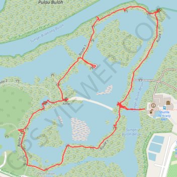
Name: Sungei Buloh Wetland Route trail, distance, elevation, map, profile, GPS track
Coordinates: 1.44398 103.72410 1.44970 103.72903
Other hiking, mountain biking, running and outdoor activity trails
Click on a trail to view its statistics, map and profile.
Directions from Duck Tour Ramp to Marina Boulevard, Singapore
Distance: 105.3 Km • Elevation gain: 812 m • Maximum elevation: 51 m