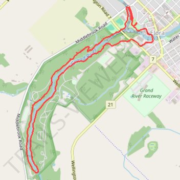
Elora Gorge hiking & exploring
- Distance: 8.3 Km
- Elevation gain: 106 m
- Maximum elevation: 387 m
- Elevation loss: 106 m
- Minimum elevation: 346 m
- Moving time: 2 h 21 m
- Moving speed: 3.5 Km/h
- Maximum speed: 6.3 Km/h
- Total time: 2 h 51 m
- Global speed: 2.9 Km/h
Interactive trail map
Trail profile
- Distance: 8.3 Km
- Elevation gain: 106 m
- Maximum elevation: 387 m
- Elevation loss: 106 m
- Minimum elevation: 346 m
- Moving time: 2 h 21 m
- Moving speed: 3.5 Km/h
- Maximum speed: 6.3 Km/h
- Total time: 2 h 51 m
- Global speed: 2.9 Km/h
About this trail
Name: Elora Gorge hiking & exploring trail, distance, elevation, map, profile, GPS track
Coordinates: 43.66282 -80.45321 43.68456 -80.43025
Other hiking, mountain biking, running and outdoor activity trails
Click on a trail to view its statistics, map and profile.
Ontario country roads
Distance: 150.4 Km • Elevation gain: 1,137 m • Maximum elevation: 497 m