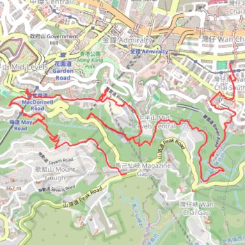
荷兰径
Outdoor walk
- Distance: 8.6 Km
- Elevation gain: 718 m
- Maximum elevation: 333 m
- Elevation loss: 477 m
- Minimum elevation: 27 m
- Moving time: 2 h 33 m
- Moving speed: 3.3 Km/h
- Maximum speed: 18.8 Km/h
- Total time: 4 h 10 m
- Global speed: 2.1 Km/h
Interactive trail map
Trail profile
About this trail
Name: 荷兰径 trail, distance, elevation, map, profile, GPS track
Coordinates: 22.26823 114.15498 22.27711 114.17332
Other hiking, mountain biking, running and outdoor activity trails
Click on a trail to view its statistics, map and profile.
金鴨中段 灣仔峽南坑右源 灣仔峽北坑
China > Hong Kong > Hong Kong Island
Hong Kong Island Hike
Distance: 3.7 Km • Elevation gain: 199 m • Maximum elevation: 255 m
HK dino
China > Hong Kong > Hong Kong Island
Loop hike from Kennedy Town via Lung Fu Shan, High West, Victoria Peak, Pok Fu Lam Reservoir and Mount Davis in the Lung Fu Shan Country Park and the Pok Fu Lam Country Park. #Hiking #Loop #Nature #Mountain #Forest #Sea #Pacific #Ocean #Park
Distance: 24.4 Km • Elevation gain: 1,325 m • Maximum elevation: 529 m
Hong Kong island ride
China > Hong Kong > Hong Kong Island
#Bike
Distance: 61.8 Km • Elevation gain: 2,152 m • Maximum elevation: 505 m
Central Hong Kong - Pok Fu Lam Country Park
China > Hong Kong > Hong Kong Island
Distance: 7.4 Km • Elevation gain: 431 m • Maximum elevation: 401 m
Wilson Trail Full Route
China > Hong Kong > Hong Kong Island
Distance: 81.2 Km • Elevation gain: 4,430 m • Maximum elevation: 613 m
Trail Planner Map
China > Hong Kong > Hong Kong Island
Distance: 20.3 Km • Elevation gain: 1,151 m • Maximum elevation: 423 m
金馬倫北坑 金馬倫西坑
China > Hong Kong > Hong Kong Island
Distance: 4.0 Km • Elevation gain: 340 m • Maximum elevation: 399 m