
Mount Fremont Lookout
From Sunrise in Yakima Park, the route climbs through open subalpine meadows onto Sourdough Ridge, with Mount Rainier and the Burroughs Mountain area gradually opening behind and beside the path.
Near Frozen Lake, the trail leaves the busier junction area and continues onto the Mount Fremont Lookout Trail, traversing a more exposed, rocky ridge along the flank of Mount Fremont.
The final approach reaches the historic Mount Fremont Fire Lookout, a high, wind-swept viewpoint over the surrounding ridges, meadows, basins, and the broad alpine face of Mount Rainier.
#Hiking #Mountain #Lake #Nature #Rainier #Lookout #Ridge #Meadow #Viewpoint
- Distance: 9.2 Km
- Elevation gain: 370 m
- Maximum elevation: 2,181 m
- Elevation loss: 370 m
- Minimum elevation: 1,950 m
Interactive trail map
Trail profile
- Distance: 9.2 Km
- Elevation gain: 370 m
- Maximum elevation: 2,181 m
- Elevation loss: 370 m
- Minimum elevation: 1,950 m
About this trail
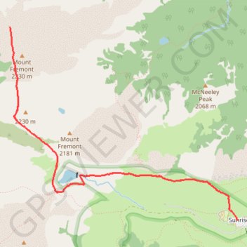
Name: Mount Fremont Lookout trail, distance, elevation, map, profile, GPS track
Start: Sunrise Rim, Sunrise, Pierce County, Washington, United States (46.91483 -121.64242)
End: Sunrise Rim, Sunrise, Pierce County, Washington, United States (46.91483 -121.64242)
Coordinates: 46.91483 -121.67538 46.93384 -121.64242
Other hiking, mountain biking, running and outdoor activity trails
Click on a trail to view its statistics, map and profile.
Northern part of the Pacific Crest Trail (PCT)
United States > Oregon > Klamath County
Hike on the Pacific Crest National Scenic Trail from Crater Lake to Canada Border through Oregon and Washington along the Sierra Nevada and Cascade mountain ranges. #Hiking #Mountain #SierraNevada #Cascade #Nature #Forest #Park #PCT
Distance: 1,198.3 Km • Elevation gain: 44,308 m • Maximum elevation: 2,307 m

Hiking out to 3rd Burroughs Mountain near Rainier
United States > Washington > Pierce County > Sunrise
Distance: 14.4 Km • Elevation gain: 751 m • Maximum elevation: 2,383 m