Thank you for supporting this site ❤️
Make a donation
Make a donation
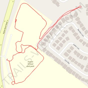
Skyline Ranch Park Loop Walk
- Distance: 1.5 Km
- Elevation gain: 71 m
- Maximum elevation: 585 m
- Elevation loss: 72 m
- Minimum elevation: 532 m
- Moving time: 24 m 4 s
- Moving speed: 3.9 Km/h
- Maximum speed: 6.9 Km/h
- Total time: 27 m 11 s
- Global speed: 3.4 Km/h
Interactive trail map
Thank you for supporting this site ❤️
Make a donation
Make a donation
Trail profile
- Distance: 1.5 Km
- Elevation gain: 71 m
- Maximum elevation: 585 m
- Elevation loss: 72 m
- Minimum elevation: 532 m
- Moving time: 24 m 4 s
- Moving speed: 3.9 Km/h
- Maximum speed: 6.9 Km/h
- Total time: 27 m 11 s
- Global speed: 3.4 Km/h
Thank you for supporting this site ❤️
Make a donation
Make a donation
About this trail
Name: Skyline Ranch Park Loop Walk trail, distance, elevation, map, profile, GPS track
Coordinates: 34.43507 -118.45791 34.43794 -118.45472
Thank you for supporting this site ❤️
Make a donation
Make a donation