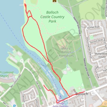
Balloch Castle Country Park
- Distance: 3.2 Km
- Elevation gain: 33 m
- Maximum elevation: 20 m
- Elevation loss: 29 m
- Minimum elevation: 8 m
- Moving time: 43 m 24 s
- Moving speed: 4.4 Km/h
- Maximum speed: 7.7 Km/h
- Total time: 1 h 4 m
- Global speed: 2.9 Km/h
Interactive trail map
Trail profile
- Distance: 3.2 Km
- Elevation gain: 33 m
- Maximum elevation: 20 m
- Elevation loss: 29 m
- Minimum elevation: 8 m
- Moving time: 43 m 24 s
- Moving speed: 4.4 Km/h
- Maximum speed: 7.7 Km/h
- Total time: 1 h 4 m
- Global speed: 2.9 Km/h
About this trail
Name: Balloch Castle Country Park trail, distance, elevation, map, profile, GPS track
Start: Pier Road, Balloch, West Dunbartonshire, Scotland, G83 8SE, United Kingdom (56.00483 -4.58538)
Coordinates: 56.00310 -4.58904 56.01265 -4.57838
Other hiking, mountain biking, running and outdoor activity trails
Click on a trail to view its statistics, map and profile.