Mount Whitney
Hike to Mount Whitney via Mount Whitney Trail, Lone Pine Lake, Mirror Lake, Consultation Lake, Trail Crest and John Muir Trail in John Muir Wilderness. #Hiking #Mountain #Nature #Wilderness #Muir #Forest #Lake
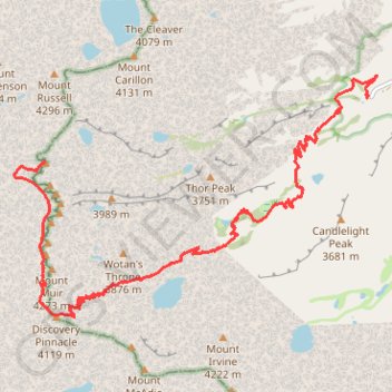
- Distance: 16.9 Km
- Elevation gain: 2,175 m
- Maximum elevation: 4,415 m
- Elevation loss: 329 m
- Minimum elevation: 2,551 m
Interactive trail map
Trail profile
- Distance: 16.9 Km
- Elevation gain: 2,175 m
- Maximum elevation: 4,415 m
- Elevation loss: 329 m
- Minimum elevation: 2,551 m
About this trail
Name: Mount Whitney trail, distance, elevation, map, profile, GPS track
Start: Mount Whitney Trail, Inyo County, California, United States (36.58689 -118.24015)
End: John Muir Trail, Tulare County, California, United States (36.57858 -118.29215)
Coordinates: 36.55853 -118.29713 36.58999 -118.23858
Other hiking, mountain biking, running and outdoor activity trails
Click on a trail to view its statistics, map and profile.
Lone Pine Lake
United States > California > Inyo County
Starting at Whitney Portal, a wooded canyon at the end of Whitney Portal Road, the route follows the Mount Whitney Trail past the North Fork of Lone Pine Creek and into the John Muir Wilderness, with granite walls and the Mount Whitney massif framing the ascent. It then climbs through conifer forest on a…
Distance: 4.7 Km • Elevation gain: 549 m • Maximum elevation: 3,067 m