Thank you for supporting this site ❤️
Make a donation
Make a donation
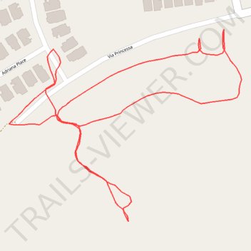
Via Princessa hills
- Distance: 1.3 Km
- Elevation gain: 43 m
- Maximum elevation: 494 m
- Elevation loss: 43 m
- Minimum elevation: 458 m
- Moving time: 23 m 31 s
- Moving speed: 3.3 Km/h
- Maximum speed: 6.5 Km/h
- Total time: 26 m 40 s
- Global speed: 2.9 Km/h
Interactive trail map
Thank you for supporting this site ❤️
Make a donation
Make a donation
Trail profile
- Distance: 1.3 Km
- Elevation gain: 43 m
- Maximum elevation: 494 m
- Elevation loss: 43 m
- Minimum elevation: 458 m
- Moving time: 23 m 31 s
- Moving speed: 3.3 Km/h
- Maximum speed: 6.5 Km/h
- Total time: 26 m 40 s
- Global speed: 2.9 Km/h
Thank you for supporting this site ❤️
Make a donation
Make a donation
About this trail
Name: Via Princessa hills trail, distance, elevation, map, profile, GPS track
Coordinates: 34.40796 -118.49110 34.41013 -118.48792
Thank you for supporting this site ❤️
Make a donation
Make a donation