
Sugar Pine Reservoir Loop
Starting near the Sugar Pine boat-ramp area, this anti-clockwise loop follows the Joshua M. Hardt Memorial Trail along the eastern shore of Sugar Pine Reservoir, with broad lake views, wooded slopes and the quiet backdrop of Tahoe National Forest.
The route then rounds the northern coves and inlets, passing through pine forest and shoreline viewpoints before continuing down the western side of the reservoir toward Sugar Pine Dam.
After crossing the dam area, the trail returns along the southern lakeshore, completing a calm lake-and-forest circuit shaped by water, woodland, mountain foothills and reservoir scenery.
#Hiking #Loop #Lake #Mountain #Nature #Forest #Dam #Reservoir #Shoreline
- Distance: 7.0 Km
- Elevation gain: 161 m
- Maximum elevation: 1,133 m
- Elevation loss: 161 m
- Minimum elevation: 1,097 m
- Moving time: 1 h 47 m
- Moving speed: 3.9 Km/h
- Maximum speed: 6.0 Km/h
- Total time: 1 h 58 m
- Global speed: 3.5 Km/h
Interactive trail map
Trail profile
- Distance: 7.0 Km
- Elevation gain: 161 m
- Maximum elevation: 1,133 m
- Elevation loss: 161 m
- Minimum elevation: 1,097 m
- Moving time: 1 h 47 m
- Moving speed: 3.9 Km/h
- Maximum speed: 6.0 Km/h
- Total time: 1 h 58 m
- Global speed: 3.5 Km/h
About this trail
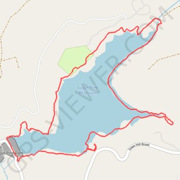
Name: Sugar Pine Reservoir Loop trail, distance, elevation, map, profile, GPS track
Start: Joshua M. Hardt Memorial Trail, Placer County, California, United States (39.13011 -120.79130)
End: Joshua M. Hardt Memorial Trail, Placer County, California, United States (39.13016 -120.79127)
Coordinates: 39.12862 -120.80141 39.14144 -120.78217