
Digley and Ramsden Reservoirs Loop Walk
- Distance: 6.4 Km
- Elevation gain: 166 m
- Maximum elevation: 308 m
- Elevation loss: 165 m
- Minimum elevation: 183 m
- Moving time: 2 h 27 m
- Moving speed: 2.6 Km/h
- Maximum speed: 6.6 Km/h
- Total time: 3 h 32 m
- Global speed: 1.8 Km/h
Interactive trail map
Trail profile
- Distance: 6.4 Km
- Elevation gain: 166 m
- Maximum elevation: 308 m
- Elevation loss: 165 m
- Minimum elevation: 183 m
- Moving time: 2 h 27 m
- Moving speed: 2.6 Km/h
- Maximum speed: 6.6 Km/h
- Total time: 3 h 32 m
- Global speed: 1.8 Km/h
About this trail
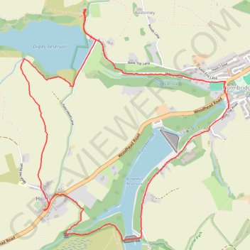
Name: Digley and Ramsden Reservoirs Loop Walk trail, distance, elevation, map, profile, GPS track
Coordinates: 53.54736 -1.84133 53.56205 -1.81908
Other hiking, mountain biking, running and outdoor activity trails
Click on a trail to view its statistics, map and profile.
Netherthong to Holmebridge via Upperthong (HVCW)
United Kingdom > England > Kirklees > Netherthong > Deanhouse
Netherthong - Deanhouse - Upperthong - Hogley Green - Booth House - Carr Green - Hinchliffe Mill - Holmbridge - Flush House - Austonley - Digley Reservoir - River Holme
Distance: 7.0 Km • Elevation gain: 192 m • Maximum elevation: 287 m