
Forest Lakes Loop Trail in James Peak Wilderness Area
The Forest Lakes Loop Trail offers a picturesque journey through the heart of the James Peak Wilderness Area. As you hike, you'll pass through serene aspen groves, rugged forested sections, and creekside paths, providing an immersive natural experience. The trail rewards adventurers with views of two stunning alpine lakes, surrounded by rocky terrain and mountain vistas, making it a memorable outing for those seeking a peaceful yet challenging route. #Hiking #Loop #Lake #Mountain #Forest #Nature
- Distance: 10.5 Km
- Elevation gain: 468 m
- Maximum elevation: 3,261 m
- Elevation loss: 462 m
- Minimum elevation: 2,810 m
Interactive trail map
Trail profile
- Distance: 10.5 Km
- Elevation gain: 468 m
- Maximum elevation: 3,261 m
- Elevation loss: 462 m
- Minimum elevation: 2,810 m
About this trail
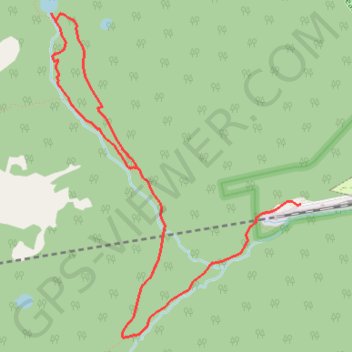
Name: Forest Lakes Loop Trail in James Peak Wilderness Area trail, distance, elevation, map, profile, GPS track
End: South Boulder Creek Trail, Gilpin County, Colorado, United States (39.90329 -105.64482)
Coordinates: 39.89338 -105.66734 39.91692 -105.64382
Other hiking, mountain biking, running and outdoor activity trails
Click on a trail to view its statistics, map and profile.
Crater Lakes via South Boulder Creek
United States > Colorado > Gilpin County > East Portal Distributed Camping Area
Starting at the Moffat Tunnel East Portal, the route enters Roosevelt National Forest and follows the South Boulder Creek Trail into the James Peak Wilderness, passing dense subalpine forest, creekside clearings, and the Forest Lakes Trail junction before turning onto the signed Crater Lakes Trail. The climb…
Distance: 11.0 Km • Elevation gain: 559 m • Maximum elevation: 3,364 m