Tripyramid Mountains Loop
Loop hike from Livermore South Trailhead to North Tripyramid, Middle Tripyramid and South Tripyramid via Livermore Road, Avalanche Brook, Mount Tripyramid Trail and Slide Brook in the Sandwich Range Wilderness. #Hiking #Loop #Mountain #Forest #Nature #Wilderness
- Distance: 17.1 Km
- Elevation gain: 854 m
- Maximum elevation: 1,246 m
- Elevation loss: 854 m
- Minimum elevation: 475 m
- Moving time: 4 h 25 m
- Moving speed: 3.9 Km/h
- Maximum speed: 5.9 Km/h
- Total time: 6 h 56 m
- Global speed: 2.5 Km/h
Interactive trail map
Trail profile
- Distance: 17.1 Km
- Elevation gain: 854 m
- Maximum elevation: 1,246 m
- Elevation loss: 854 m
- Minimum elevation: 475 m
- Moving time: 4 h 25 m
- Moving speed: 3.9 Km/h
- Maximum speed: 5.9 Km/h
- Total time: 6 h 56 m
- Global speed: 2.5 Km/h
About this trail
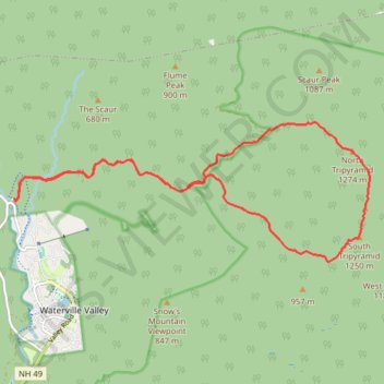
Name: Tripyramid Mountains Loop trail, distance, elevation, map, profile, GPS track
Coordinates: 43.95656 -71.51332 43.97753 -71.43910
Other hiking, mountain biking, running and outdoor activity trails
Click on a trail to view its statistics, map and profile.
North Tripyramid, Middle Tripyramid and South Tripyramid
United States > New Hampshire > Grafton County
Starting from the Pine Bend Brook Trailhead on the Kancamagus Highway, the route enters the White Mountain National Forest and follows Pine Bend Brook into the Sandwich Range Wilderness, moving through a quiet forested drainage below Scaur Peak and The Fool Killer. The climb then steepens toward the Tripyramid…
Distance: 15.4 Km • Elevation gain: 1,020 m • Maximum elevation: 1,244 m