
Buckskin Gulch
From Wire Pass Trailhead, the hike follows the sandy course of Coyote Wash along the Wire Pass Trail, crossing open desert before the wash tightens into Wire Pass Slot Canyon. Smooth sandstone walls, shaded narrows, and a nearby petroglyph panel lead toward the junction with Buckskin Gulch.
At this junction, the itinerary first turns onto Buckskin Gulch Trail, entering the main canyon corridor and passing Buckskin Overlook along this branch of the route. The passage follows sandy bends, pale slickrock, dry washes, and undulating sandstone walls before returning to the Wire Pass junction.
Back at the junction, the route then follows Upper Buckskin Gulch Trail in the opposite direction, exploring another arm of the canyon system before turning back. The return retraces the junction, Wire Pass Slot Canyon, Coyote Wash, and the open desert approach to the trailhead, within the Grand Staircase–Escalante and Paria Canyon–Vermilion Cliffs wilderness landscape.
#Hiking #Nature #Canyon #Desert #Overlook #Wilderness #Slot #Sandstone #Adventure
- Distance: 16.7 Km
- Elevation gain: 381 m
- Maximum elevation: 1,486 m
- Elevation loss: 381 m
- Minimum elevation: 1,441 m
- Moving time: 2 h 2 m
- Moving speed: 8.2 Km/h
- Maximum speed: 28.3 Km/h
- Total time: 2 h 2 m
- Global speed: 8.2 Km/h
Interactive trail map
Trail profile
- Distance: 16.7 Km
- Elevation gain: 381 m
- Maximum elevation: 1,486 m
- Elevation loss: 381 m
- Minimum elevation: 1,441 m
- Moving time: 2 h 2 m
- Moving speed: 8.2 Km/h
- Maximum speed: 28.3 Km/h
- Total time: 2 h 2 m
- Global speed: 8.2 Km/h
About this trail
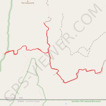
Name: Buckskin Gulch trail, distance, elevation, map, profile, GPS track
Start: Wire Pass Trail, Kane County, Utah, United States (37.01910 -112.02485)
End: House Rock Valley Road, Kane County, Utah, United States (37.01909 -112.02487)
Coordinates: 37.00754 -112.02487 37.03133 -111.97616
Other hiking, mountain biking, running and outdoor activity trails
Click on a trail to view its statistics, map and profile.
The Wave
United States > Utah > Kane County
From Wire Pass Trailhead, the route leaves House Rock Valley Road and follows the open desert toward Wire Pass, crossing sandy washes and sparse high-desert flats before entering the remote backcountry of Coyote Buttes North, a permit-only section of the Paria Canyon–Vermilion Cliffs Wilderness known for its…
Distance: 4.5 Km • Elevation gain: 213 m • Maximum elevation: 1,595 m
The Wave Trail in Vermilion Cliffs National Monument
United States > Utah > Kane County
The Wave Trail in Vermilion Cliffs National Monument offers hikers a journey through a landscape of undulating sandstone formations, vibrant red and orange hues, and expansive vistas of the surrounding desert terrain. The path meanders across varied terrains, including sandy stretches and smooth rock surfaces,…
Distance: 9.0 Km • Elevation gain: 288 m • Maximum elevation: 1,588 m