
The Wave
From Wire Pass Trailhead, the route leaves House Rock Valley Road and follows the open desert toward Wire Pass, crossing sandy washes and sparse high-desert flats before entering the remote backcountry of Coyote Buttes North, a permit-only section of the Paria Canyon–Vermilion Cliffs Wilderness known for its fragile sandstone scenery.
Beyond the first wash corridors, the itinerary turns across pale slickrock, low ridges and sculpted Navajo sandstone, with the Vermilion Cliffs landscape opening around the route; Plateau Rock appears as a useful landmark before the terrain becomes increasingly marked by rounded domes, shallow bowls, fins and striped stone.
The final approach reaches the celebrated formation of The Wave, where flowing bands of red, orange, cream and pink sandstone create a natural amphitheater of cross-bedded rock, surrounded by the quiet desert textures of Coyote Buttes North and the broader Vermilion Cliffs wilderness.
#Hiking #Nature #Rock #Wilderness #Desert #Sandstone #Slickrock #Canyon
- Distance: 4.5 Km
- Elevation gain: 213 m
- Maximum elevation: 1,595 m
- Elevation loss: 104 m
- Minimum elevation: 1,472 m
- Moving time: 2 h 52 m
- Moving speed: 1.6 Km/h
- Maximum speed: 3.0 Km/h
- Total time: 4 h 10 m
- Global speed: 1.1 Km/h
Interactive trail map
Trail profile
- Distance: 4.5 Km
- Elevation gain: 213 m
- Maximum elevation: 1,595 m
- Elevation loss: 104 m
- Minimum elevation: 1,472 m
- Moving time: 2 h 52 m
- Moving speed: 1.6 Km/h
- Maximum speed: 3.0 Km/h
- Total time: 4 h 10 m
- Global speed: 1.1 Km/h
About this trail
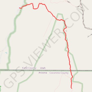
Name: The Wave trail, distance, elevation, map, profile, GPS track
Start: House Rock Valley Road, Kane County, Utah, United States (37.01903 -112.02506)
End: The Loop, Coconino County, Arizona, United States (36.99572 -112.00603)
Coordinates: 36.99572 -112.02506 37.02037 -112.00573
Other hiking, mountain biking, running and outdoor activity trails
Click on a trail to view its statistics, map and profile.
The Wave Trail in Vermilion Cliffs National Monument
United States > Utah > Kane County
The Wave Trail in Vermilion Cliffs National Monument offers hikers a journey through a landscape of undulating sandstone formations, vibrant red and orange hues, and expansive vistas of the surrounding desert terrain. The path meanders across varied terrains, including sandy stretches and smooth rock surfaces,…
Distance: 9.0 Km • Elevation gain: 288 m • Maximum elevation: 1,588 m
Buckskin Gulch
United States > Utah > Kane County
From Wire Pass Trailhead, the hike follows the sandy course of Coyote Wash along the Wire Pass Trail, crossing open desert before the wash tightens into Wire Pass Slot Canyon. Smooth sandstone walls, shaded narrows, and a nearby petroglyph panel lead toward the junction with Buckskin Gulch. At this junction,…
Distance: 16.7 Km • Elevation gain: 381 m • Maximum elevation: 1,486 m